GET2DAACHOPPAAAA
Member
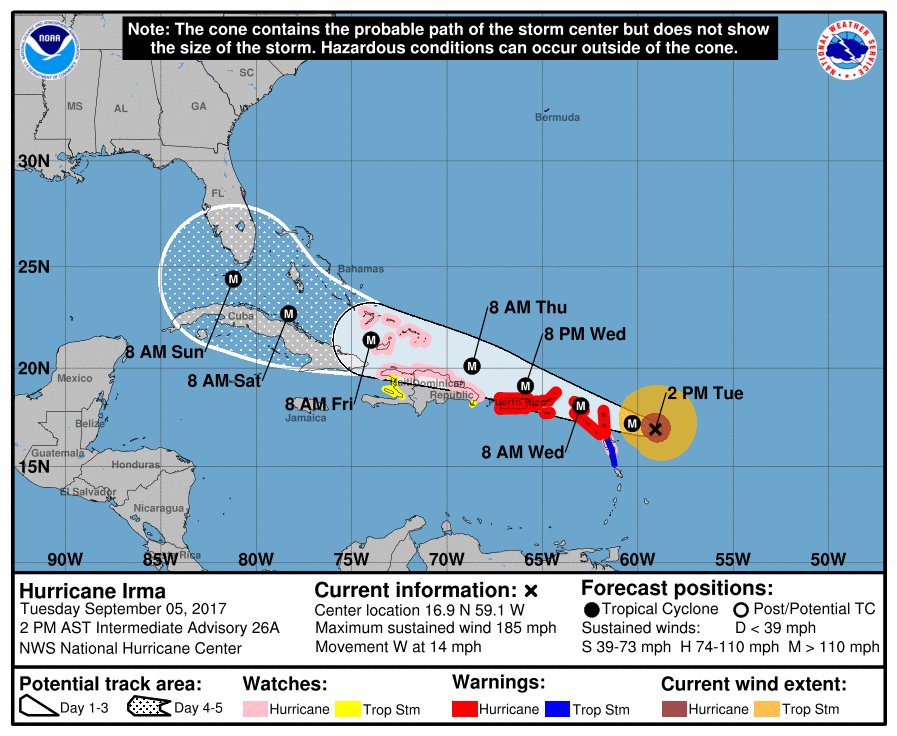
You aren't kidding... Landfall around the GA\SC border...
Shit I'm in Savannah....
You aren't kidding... Landfall around the GA\SC border...
At Puerto Rico right now. Kind of scary, I don't think we are prepared for an hurricane of this magnitude.
Center keeps inching closer and closer to us.
Bad news for Georgia this time. Probably the strongest for that state since 1898? If it happened. Still a long way to go and the tracks will change...

Wait I thought it was hitting south west Florida. Or is this after it skips over Florida? I am in Charleston SC. Hell
So how's it looking for Boca Raton?
This may be a dumb question, but do I have any reason to be concerned for my flight out of Boston to LAX on the 17th?
Wait I thought it was hitting south west Florida. Or is this after it skips over Florida? I am in Charleston SC. Hell

Thank you. Figured I was being paranoid, just wanted to make sure.Not in the least.
My apartment complex just sent an email out saying that if it's a Category 1 or higher there is MANDATORY evacuation? Wow... guess I'm not staying home.
My apartment complex just sent an email out saying that if it's a Category 1 or higher there is MANDATORY evacuation? Wow... guess I'm not staying home.

Wow. What's your building made of? Sticks and duct tape?
You must live in Plan A then:
http://www.broward.org/Hurricane/Documents/EmergencyShelterMapWebBiggerS.jpg
Latest UKMET model looks exceptionally strong too. Not just the GFS now.
Yeah we live on South Ocean Drive in Hollywood, so we fall under Plan A. I've only been in this apartment for six months so I'm definitely not used to this.
I live in Charleston. Fuck.
Yeah we live on South Ocean Drive in Hollywood, so we fall under Plan A. I've only been in this apartment for six months so I'm definitely not used to this.

Again, this is one of many models and the only one that is currently showing Irma skirting up the east coast of Florida.

Near Aguadilla/Isabella?I'm in the northwestern tip of Puerto Rico. My grandmother is a stubborn little old lady living in a wooden house who refuses to spend the night elsewhere. Rest of us are hunkering down in concrete houses--most houses in Puerto Rico are basically concrete fortresses. She has shrugged off all of our pleas... How worried should I be? The hurricane center is forecast to pass some miles north from the island. I know the northeast is gonna get hit the hardest, but what should we expect here at the northwest?
Wow, interesting morning.
EDIT: The last time a hurricane this big hit us it turned two islands... into one.
1) where are you?
2) how the hell did two islands become one? Please go on!
Where are you at? I'm in San Juan right now. Honestly, I think this shit hit us at the worst time possible and we're still recovering from last year's blackout.
I live in Caguas, but I think we still will get hit by gusts of 100mph or more.I work at Camuy at a warehouse, and I can tell you the amount of people that are coming to look for resources is concerning, lots of people left preparations for last minute
Yeah we live on South Ocean Drive in Hollywood, so we fall under Plan A. I've only been in this apartment for six months so I'm definitely not used to this.
My wifes family is from Caguas as well. Shes been in contact with them but shes worried for her elders for sure.I live in Caguas, but I think we still will get hit by gusts of 100mph or more.
San Juan is gonna get hit hard, the entire northeast coast. Stay safe guys.
Just looking this image , it seems they are going to an storms convention....

crazy, what are the chances for the disturbance in the gulf?
Latest Euro model is rolling out and the intensity is completely wrong from the start.
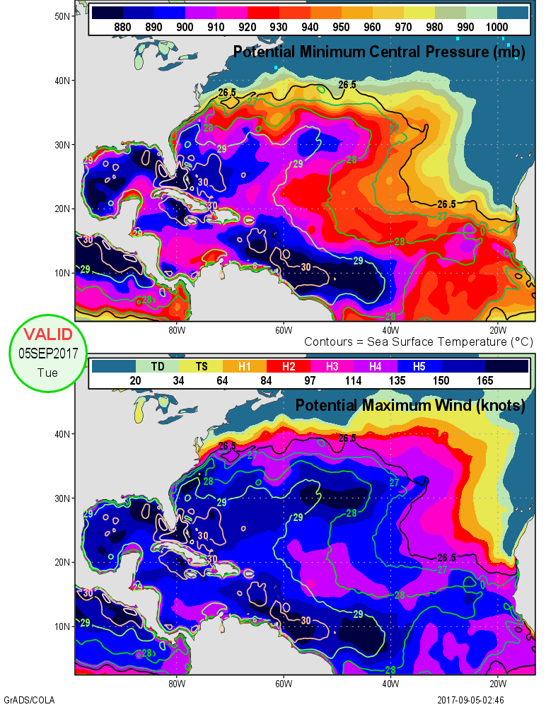
Shows it going from 962mb today to 966mb tomorrow. It's already 926mb.
Ignore intensity. The models are generally wrong about intensity.
The Euro and the NHC have the highest 4 day track verification scores for this storm right now.
I think, 70%
The intensity of a cyclone has an impact on track though. A weaker system will be steered by different steering currents than a stronger one. The overall movement so far hasn't really been too significant, it's when it gets closer to the Cuba/Florida later in the forecast period that the steering becomes critical and where the models start to diverge.